May 27-30, 2013
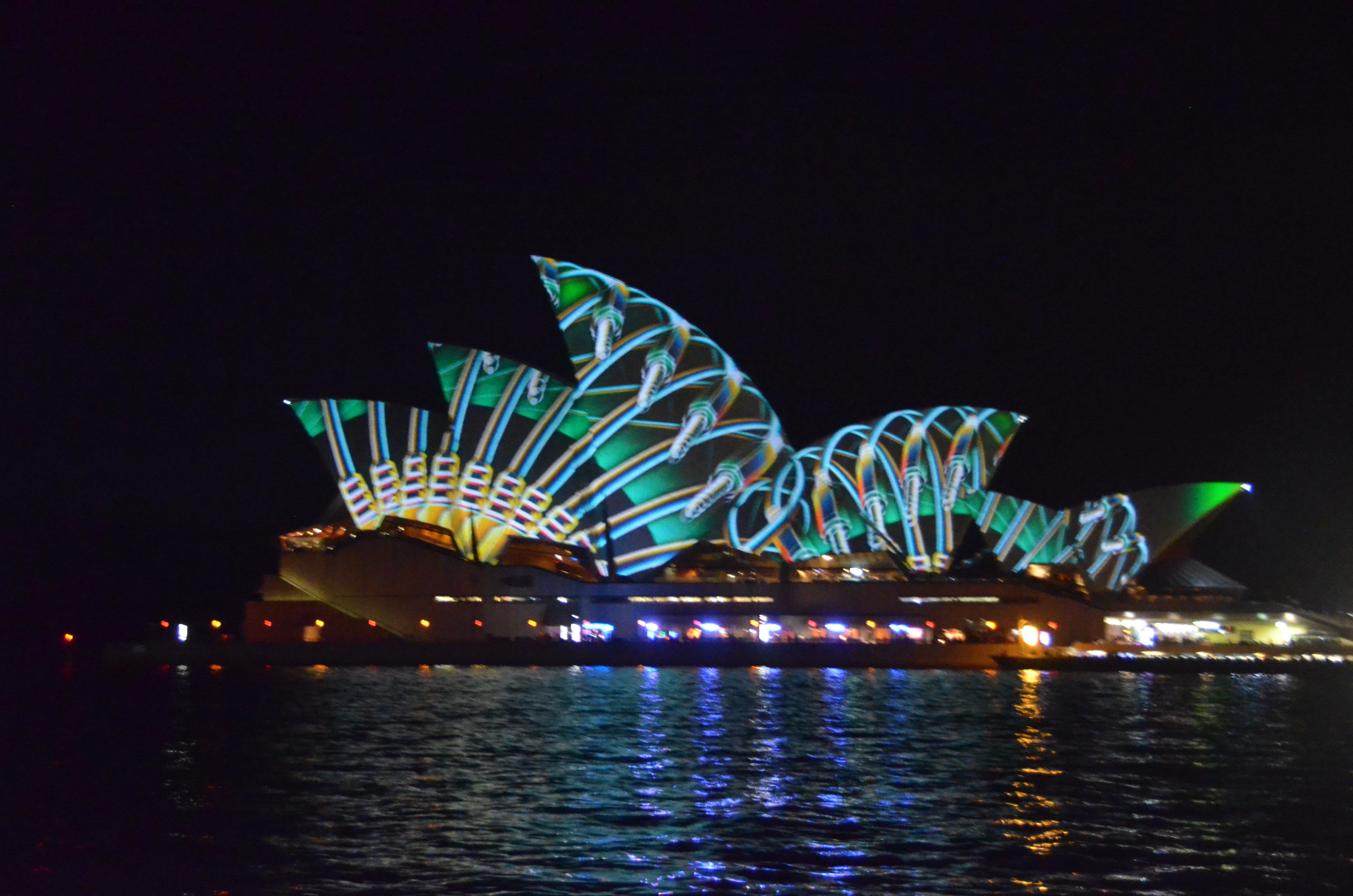
We spent four days in Sydney before sailing the Whitsundays, and Sydney was wonderful. This was the time of the annual 3-day Vivid light show when fantastic images are projected across the harbor onto the roofs of the Opera House and on other buildings. Sydney would be wonderful without Vivid, but this made it even more memorable.

Friday, May 31
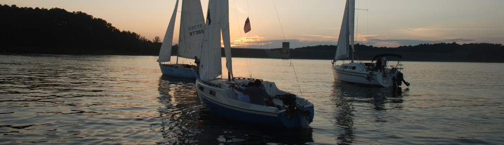
We flew Virgin Australia from Sydney to Hamilton Island, the “capital” of the Whitsunday Islands off the northeast coast of Australia. They are the jumping off point for the Great Barrier Reef and a vacation destination in themselves. The GBR doesn’t have any habitable islands, so boats leave from here or from one of the nearby towns on the mainland like Airlie Beach to take divers, snorkelers and sunbathers to the GBR.
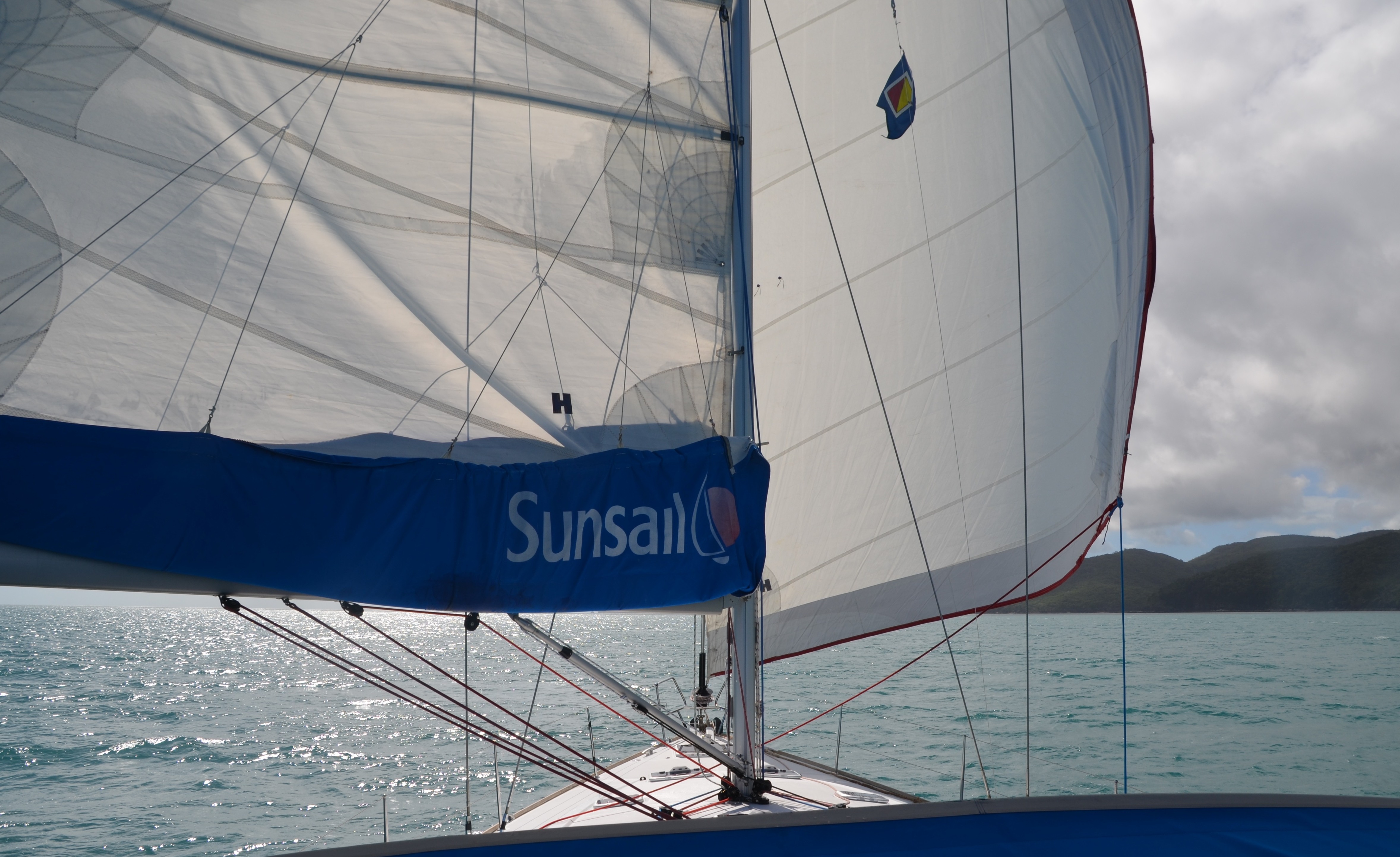
Hanna, the friendly receptionist at the Sunsail base, met us at the airport in the Sunsail van and drove us five minutes to the base in Hamilton Marina where we had a 49-foot Jeanneau waiting for us. The marina is well equipped for sailors with not only several restaurants, a general store, and a laundry, but also high end sailing shops like Slam and Henri Lloyd.
Provisions had been delivered when we arrived and had been put away by the provisioner. Nice touch. We had our chart briefing and boat briefing and settled into putting our clothes and equipment away. I went through my famous 25-point checklist to see if the boat is ready to go to sea or not. As usual, I turned up a few minor problems to be corrected the next day.
Saturday, June 1 16.0 nautical miles
The weekend staff is small at Sunsail, so it took a little while to get a few shortcomings corrected on the boat. When that was done we set sail for Cid Harbor on Whitsunday Island. It was going to be too short a sail to be satisfying so we motored south against the prevailing wind to go around the southern tip of Dent Island instead of taking the shortest route around the north end. That set up a nice long broad reach in 18-20 knots.
We passed Henning Island, Reef Point, and Cid Island before turning into Cid Harbor and making our way to Sawmill Bay. Cid is a very large and well protected harbor, but there were only a dozen boats in it, including 4 of us in Sawmill Bay.
Sunday, June 2 15.2 nm
We must have been tired. We went to bed at about 7:45 last night, and woke up at 7:30 a.m. today. I haven’t slept that long since I was a baby. The day was overcast and brooding, so bed was the best place to be anyway.
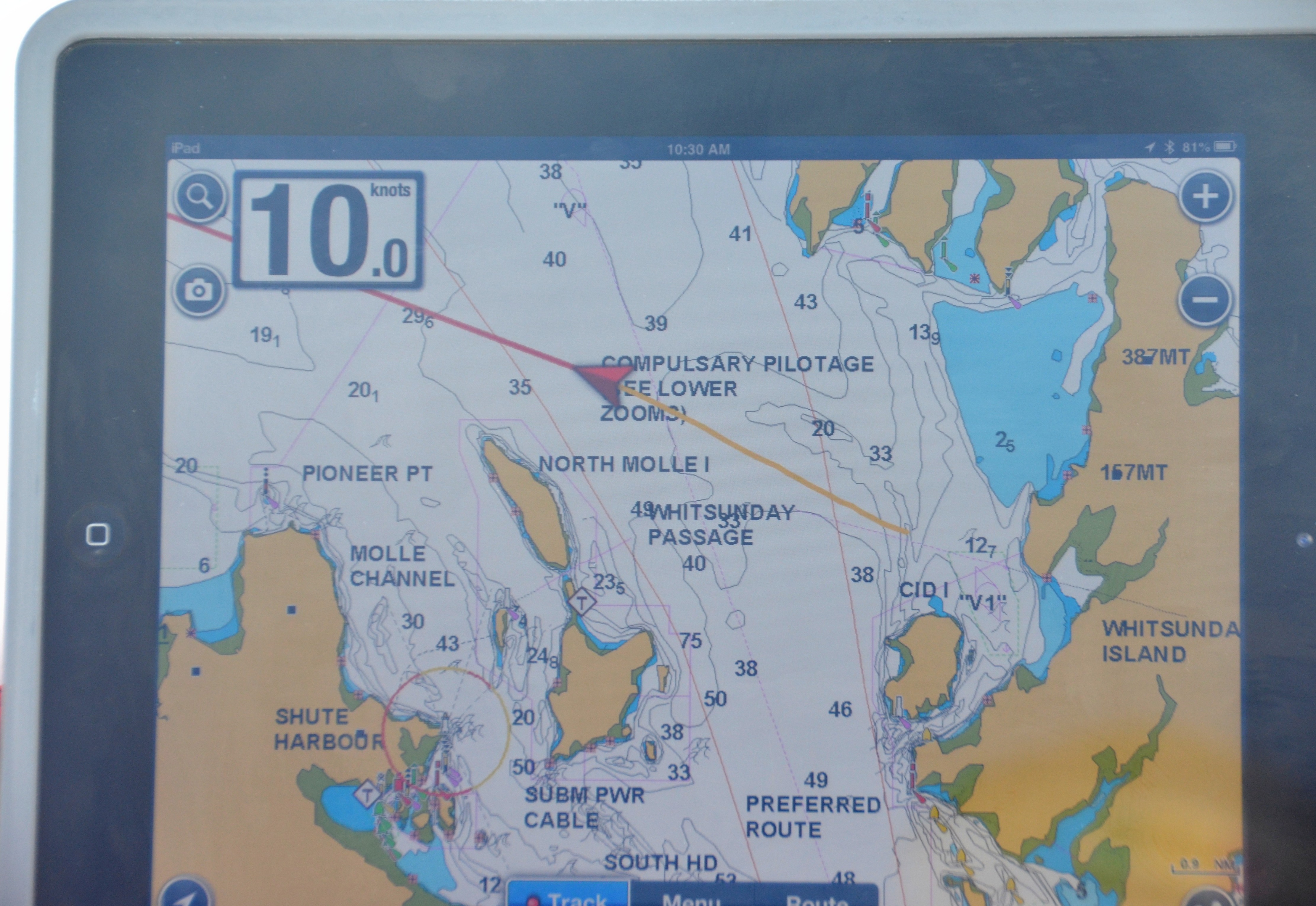
We finally got ourselves together and got underway. Passing Daniel Point and Lion Point we headed straight for the southwest corner of Hook Island. When we rounded it we put up spread sails and enjoyed a beautifully smooth ride all the way up the coast into Stonehaven Anchorage. This passage is lined with very broad reefs on both sides, so we checked our charts frequently and kept a close watch on the water ahead of us. We maintained the wing on wing sail all the way through The Narrows between Stanley Point on Hook and Groper Point on Hayman Island. Hayman is the ultra high end resort island. The others in the Whitsundays are only high end.
We finally had to drop sails and motor into Butterfly Bay where we took a mooring. This bay with wide coral reefs on three sides is shaped like a butterfly and actually has butterflies ashore.
Monday, June 3 19.6 nm
After another 12 hour sleep marathon (why can’t I sleep like that at home?) we dropped the mooring and headed out to sea to get a radio signal. The high mountains around Butterfly Bay block VHF radio waves and cell phones. After checking weather with the Sunsail base, we headed to Manta Ray Bay and Pinnacle Bay with the intention of snorkeling there. 25 knot winds with higher gusts made the water very choppy, even close to the beach, so we decided that the better part of wisdom was to skip the snorkeling and just explore the beaches from the boat.
We motored through heavy seas until we got in the lee of Hook Island. When the seas settled down our ambitions rose so we circled around Hayman Island, the snooty resort island and inspected its beaches and anchorages. Heading south we came to Langford Island, a small uninhabited island with the longest sandbar extending from it that I’ve ever seen, nearly a mile long. Even beyond the tip of the sandbar you could wade far out into the water, so we gave it wide berth and passed between it and Black Island into Stonehaven Bay. We continued south until we rounded the southwestern tip of Hook Island and headed into Nara Inlet. Nara is a fiord about two miles long, very well protected from the wind by high ridges lining both sides. It is open to the Whitsunday Passage so long swells can roll in, but that suits me fine. Gentle pitching of the boat will make for another good sleeping night.

We dinghied ashore to an Ngara Cultural Site, a place the native Ngara people had used for centuries for shelter. It still had some drawings on the side of the rocks. The park had done a very nice job of informing visitors about the site and the people. Not only were there the typical park signs explaining the history and the significance of the site, but there were recordings of eight descendants of the Ngara people reflecting on their memories of their ancestors and what it meant to live under the Aboriginal Act. One said the Ngara were people of the salt water. Maybe there is some Ngara blood in me.
A noisy visitor boarded our boat before sunset–a big white Baretta-style cockatoo. He sat on the spreader just above the Port Oliver Yacht Club burgee for a while and then when Diana put a slice of bread on the deck, he flew down and grabbed it, squawking all the way. He flew back up to the spreader and sat there eating the bread until he finally flew away to join the raucous cockatoo flock gathering in the trees onshore.

There is virtually no ambient light in Nara Inlet, so the stars look incredibly bright. While watching them from the deck of the boat, a brilliant meteor streaked across the sky and dissolved in phosphorescent green.
Tuesday, June 4 8.4 nm
Leaving Nara we threaded our way down the center of the inlet and met big rollers at its mouth. Powering through the rollers and watching a suspicious sky, we debated raising the sails long enough to make it not worth doing, so we motored to our intended destination back at Sawmill Bay again, at the foot of Whitsunday Peak. There is a 2.5 kilometer trail that ascends from the beach to the peak at 1427 feet above sea level. That is approximately the height of a 142 story building, or 1.4 times the height of the former World Trade Center.
Diana decided to stay on the boat while I hiked the trail. I stuffed some essentials into my backpack and dinghied ashore. I met a newlywed couple from Melbourne on the beach who were getting ready to hike the trail, so we started out together. I kept pace with these 30-somethings for a while, but when my heart rate maxed out, I told them to go ahead and I’ll see them later. The trail was well-marked and had good footing, but it was steep in places. With five rest stops along the way, it took me an hour and twenty-five minutes to reach the summit. The couple was still there, so we took some photos and rested. The view from the summit was truly breathtaking. I could count a dozen islands to the west and another dozen to the east. I could even see our boat at anchor down below me.

After half an hour I started back down the trail, determined to make it non-stop. About two thirds of the way down, the brakes in my knees started looking for a runaway truck ramp, but I rolled on. I caught up to the couple at the bottom of the trail, and we helped each other drag our dinghies off the beach. It took me only 45 minutes to hike back down the trail.
Back on the boat I completed my collapse as Diana prepared hot tea for me and worked on getting supper ready. I felt a sense of accomplishment–and sore muscles.
Wednesday, June 5 22.5 nm
It was a ripping good sailing day! Although the early sky was gray and negative, it brightened by the time we weighed anchor. We set off on a beam reach in 15 to 20 knots and soon were cruising at 8-9 knots. Occasionally we touched 10 knots and finally 10.6, which I’m certain is above the boat’s rated speed. When the waves in the Whitsunday Channel became too uncomfortable and we began fighting them, we jibed and fell off to a fast broad reach to Hayman Island. We still made 8 knots but it felt much smoother.
The mooring at Blue Pearl Bay was fairly calm and the coral is reputed to be excellent there so we wriggled into our wet suits with a lot of complaining and fretting, put on fins, mask, and snorkel, and hit the cold water. The wet suits helped, but it was still cold until we generated some body heat by exertion. It was a fairly good distance to the coral shelf along the shore, so we were warm by the time we got there. Unfortunately, the visibility was very poor, so the effort was mostly wasted.
As soon as we got back to the boat we dropped the mooring and motored off to Butterfly Bay, our anchorage from three days ago. We took a mooring near the entrance, even though it was rather rolly, because the coral shelf was only a few meters away, an easy swim. Since I still had my wet suit on, I couldn’t resist giving it another try, and I was glad I did. Such variety of shapes and colors I had never seen before. I particularly loved the delicate lacy coral that grew here.
Thursday, June 6 12.5 nm
“Rather rolly” was an understatement. “Very rolly’ is more accurate, but the worst part of it was the habit of the tide to push the boat forward against the mooring ball. When the hard plastic ball banged against the hull, generally against the forward part of the hull where we were sleeping, it sounded like being inside a base drum at a parade. Sleeping athwart the king sized bed converted rolling into pitching, which I don’t mind at all, but the base drum was too much.
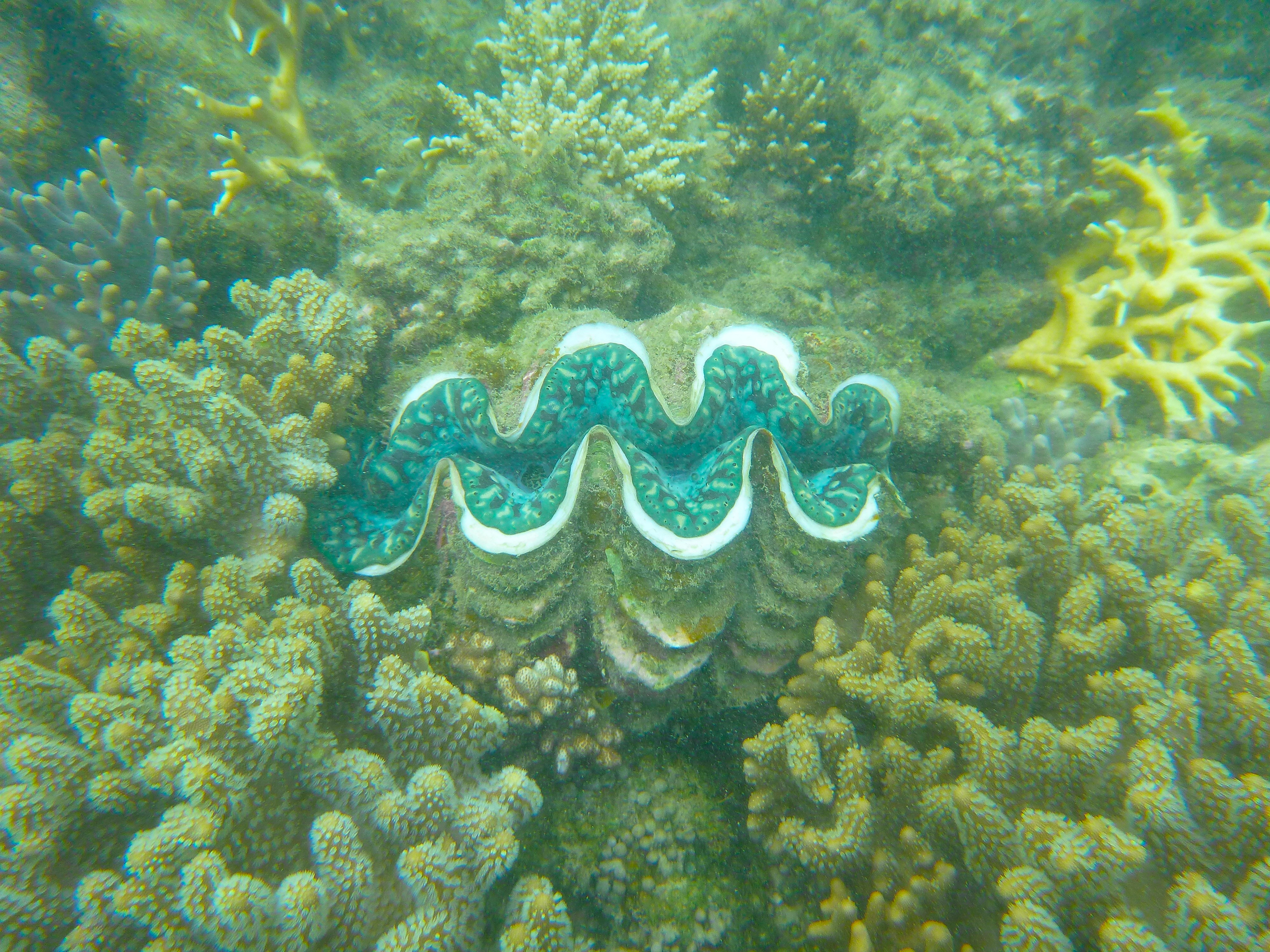
After paying the price of a much interrupted sleep, it was incumbent on us to enjoy snorkeling the nearby reef. We put on every piece of water wear we had and swam to shore. The corals were absolutely amazing in their variety and profusion. It was a very healthy reef. There were soft corals and hard corals in shapes and colors I have never seen before. But my favorite discoveries were two giant clams with blue lips. One was approximately 4 feet wide, the other about 3 feet. They were open and their nutrient filtering factories were operating.
Still pinned by strong and blustery winds from the east, we sailed down the protected west side of Hook Island and rounded up into Nara Inlet again. We went about 2 miles back in the fiord and anchored in water so still a marble would hardly roll across the deck.
Friday, June 7 17.4 nm
To sail or not to sail, that was the question. Whether ‘twas nobler to stay in a peaceful harbor or to take arms against the slings and arrows of a stormy sky and by opposing, escape it. After several tentative decisions, we chose to sail. This decision looked questionable for the next two hours as threatening skies persisted and the pervasive gray cast gloom upon everything. From the mouth of Nara Inlet to the bottleneck of Hook Passage, the seas and winds were rough, but there was no rain. After passing the small resort and underwater observatory on Hook Point we entered open sea. To our surprise, it was no rougher than what we had been experiencing, even though the wind was stronger. More than 3 hours and 15 miles later we got our first glimpse of the world famous Whitehaven Beach.
Whitehaven is rated by some travel authorities as the third most beautiful beach in the world. It consists of two and a half miles of nothing by white silica sand. No docks, no houses, no vendors, no kiosks, just sand. Behind the wide beach is luxuriant green foliage, an unusual mix of deciduous and evergreen trees and tropical foliage.

After consulting the tide charts to make our low and high tide calculations, we selected a spot in 5 meters to drop anchor. Even though the sky still looked questionable, we dinghied ashore and joined two or three dozen other tourists enjoying the wide hard packed beach.
Back onboard Avanti, we enjoyed a comfortable evening with gentle rocking of the boat, contrary to the warnings of an unpleasant rolly anchorage. We shared the harbor with only two other boats, a big private cat with a couple from Munich who have been living in Bali recently, and a Sunsail 444 cat which came in just after dark.
Saturday, June 8 0 nm, 3 miles on land
For the first time in 8 days, the morning sky was clear and blue. We decided to devote this beautiful day to walking terra firma. Having learned to be suspicious of the weather here, we packed raincoats in my backpack along with sandwiches, apples, and water. As we were preparing to go ashore, a seaplane landed with presumably VIP tourists and taxied across the water right up to the beach. Then a second seaplane landed along with two or three tourist boats. So by the time we reached the beach, it was well populated.

We walked about a mile down the beach away from the other tourists, and then walked back. As we were looking for the start of the Solway Circuit trail, we became part of a small crowd watching first one, then two, and finally four goannas that were waddling dinosaur-style around the picnic area. Goanas are monitor lizards native to Australia. These were each about 3 feet long, with stripes and spots of green, yellow and black. They had long claw feet, but seemed docile although unafraid of humans. I tried tempting them with pieces of apple, but apparently that’s not part of their diet.

The goanna watchers that had gathered were all members of the same tour group. Their host set up a barbecue, and since we were talking with several of them, he invited us to join the barbecue. We felt a little awkward crashing their barbecue, but would have felt more awkward declining their hospitality. So we had lunch with them.
After doing some hiking we went back to our dinghy which was now beached like a whale about 15 feet from the water. While we worked to drag it down to the water, a couple of Aussie guys, Jay and Ryan, came down to help us. It was a mutual assistance because they needed a ride back to their boat. This spirit of sharing, cooperating, and generally being friendly seems to typify Australians.
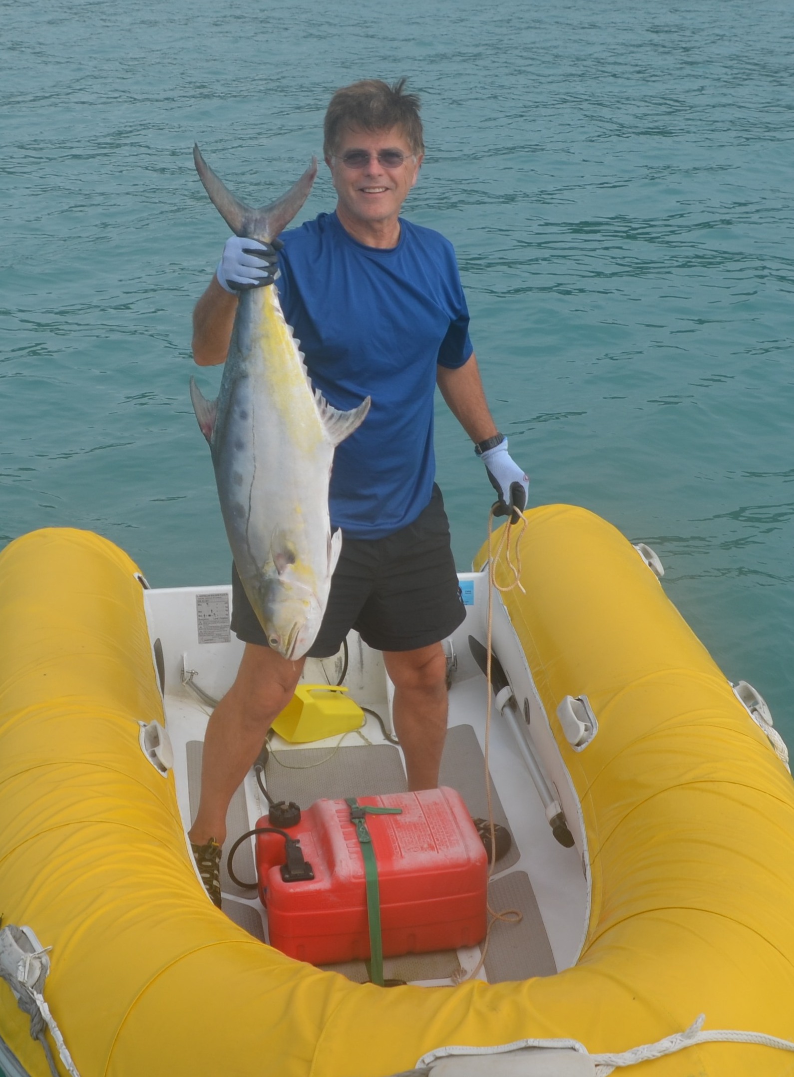
As if the day had not been full enough, after dark I went out to investigate a strange clattering sound I was hearing at the stern. I thought the dinghy was banging against the boat. I was shocked to find an 18 pound fish thrashing around inside the dinghy! I know it sounds like a fish tale, but it had jumped into our dinghy and couldn’t get out. I didn’t even have to bait a hook! I poured several buckets of salt water into the dinghy to keep him alive until morning when we could decide what to do with him. The only thing I knew for certain was that I was not going to get into the dinghy on a dark, chilly, blustery, bouncy night to fight a frantic 18 pound fish.
Sunday, June 9 12.2 nm
We identified our fish as a queenfish, a premium fish to eat, but since he had been dead for several hours in our dinghy without refrigeration, we decided to treat him as an unfortunate quirk of the ocean rather than as a meal. I climbed into the dinghy to get trophy photos and to weigh him. 17.8 pounds to be exact. We gave him a proper burial at sea.
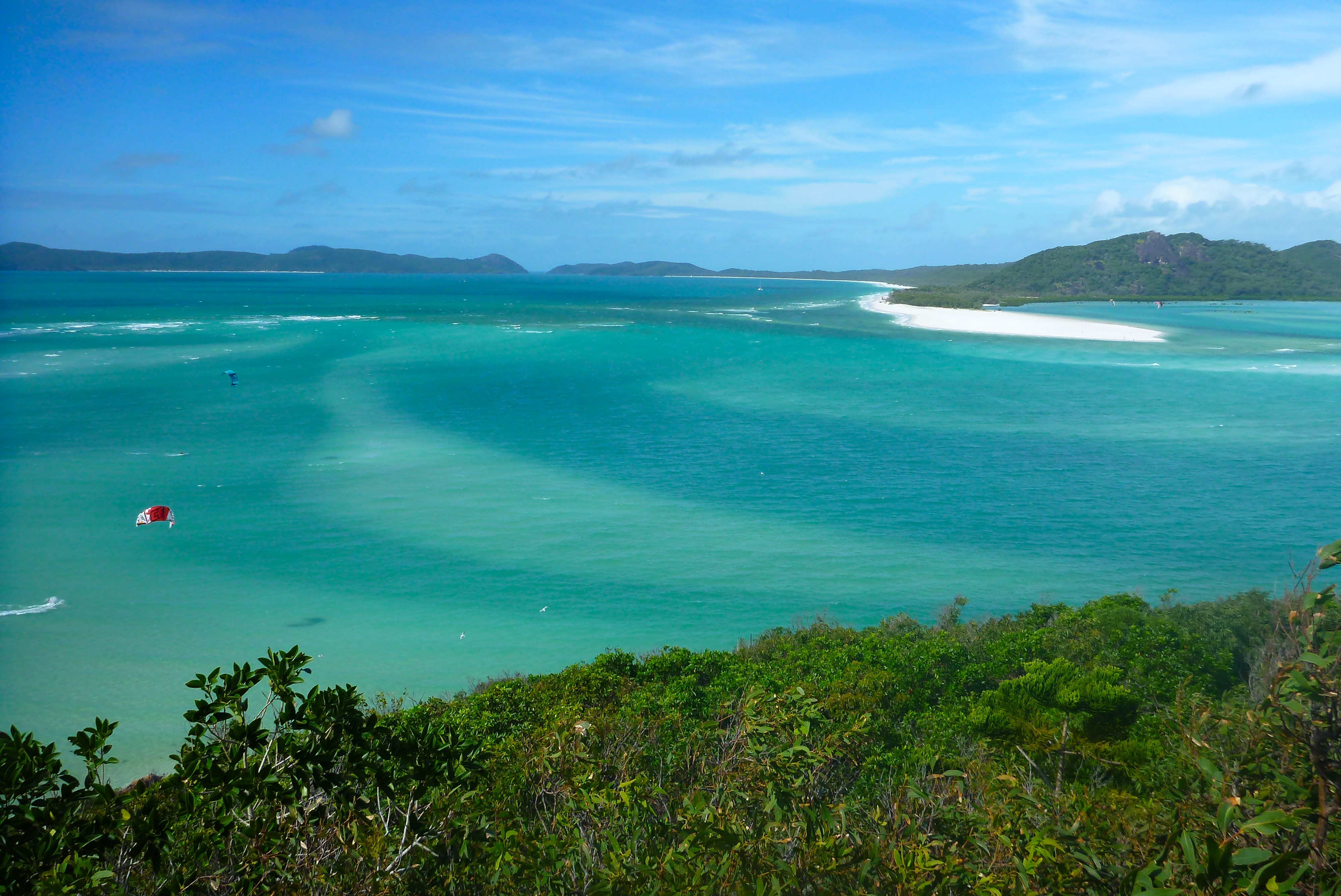
The Hill Inlet looks like a large swampy estuary on a map, but folks we met on Whitehaven Beach told us that it was a beautiful shallow inlet of the sea with swirling patterns of sand created by the tides. We sailed by it and couldn’t see anything special about it, but on good advice we rounded Tongue Point which separates Hill Inlet from Tongue Bay and dropped anchor in the Bay, also fairly shallow but navigable. There is a Whitsunday National Park trail from a beach in Tongue Bay to a lookout point over Hill Inlet, so we dinghied ashore and hiked it. Wow! Hill Inlet is a gorgeous broad spread of pure white silica sand. Imagine an oversized football field covered with white sand surrounded with water in various shades of turquoise and you almost have Hill Inlet. Add several dozen sunbathers, eight or nine kite boarders, a few manta rays swimming in the shallows, 15 knots of wind in your face, the slight smell of salt air, and breakers rolling in on the beach and the picture is as complete as I can describe.
After absorbing as much of Hill Inlet as we could, we returned to the beach where we had left our dinghy. Another dinghy was picking up people from one of the large tour boats. Nothing special about that except that the driver was dressed in a gorilla costume with a tuxedo and top hat! You don’t see that every day.
Somewhat reluctantly we departed Tongue Bay and sailed north to Cateran Bay on Border Island. We were the only boat in the bay until one came in at sunset. The wind howled all night but it was a nice steady howl so the boat rode steady on its mooring. We cracked the forward hatch open one inch and got all the ventilation we wanted.
Monday, June 10 27 nm
Part of the sky was blue and happy and part was gray and gloomy. We decided the sky was half full, so we raised the sails and sailed downwind to Pinnacle Point on the northeast corner of Hook Island. Pinnacle Point has a small lighthouse on it to warn sailors off of it, but just east of the point is Double Rock, which barely reaches the surface. These are the rocks to worry about, not the big obvious ones. They are like Chihuahuas–you don’t notice them until they slip up on you and nip you on the leg. Hitting Double Rock would be more than a nip. We spotted it and avoided it, rounded Hook Island, and breezed through the Narrows, a one mile stretch of good water between two large reefs a quarter mile apart. After a short stop at Langford Island’s one mile long sand bar, we sailed on and finally motored into Sawmill Bay, a large, pretty, and comfortable anchorage. Being our third night in Sawmill, it’s beginning to feel like home.

Tuesday, June 11 17.2 nm
From our first day on Hamilton Island we have been warned about three difficult passages: the Hunt Channel, the Fitzalan Passage, and the dreaded Solway Passage. These are pinch points where tidal flow and winds can create very rough waves, confused water, eddies, swirls, overfalls, etc. Having pretty much explored all of the bays, beaches, and inlets of the three major islands, we decided to live dangerously and challenge all three of these hot spots. Except for some 6-8 foot waves in the open ocean between Fitzalan and Solway, all three turned out to be cream puffs. We hedged our bet by entering the Solway Passage on an ebb tide just past slack water, but the experience of these mythic passages was quite a bit less than the anticipation. We will get to do Solway and Fitzalan again tomorrow.
Transiting the Solway Passage put us at the southern end of Whitehaven Beach, the exquisite 4 mile white sand beach we had visited previously from its north end. We anchored, ate lunch onboard quickly and dingied ashore to hike a trail through the woodlands to a beach on the other side. We had seen the beach and it didn’t begin to compare with Whitehaven Beach, but that wasn’t the point. The trail would be an interesting nature trek and a good opportunity to stretch our legs. 4 miles of mixed woodland and tropical vegetation later, our legs were adequately stretched. When we got back to the beach, all the boats were gone except ours, and the only new footprints in the sand were ours.
Wednesday, June 12 13.2 nm
After 12 days of howling wind, we awoke to a whisp of breeze that would be a disappointment on Barren River Lake. But when we raised our sails–nothing. So we motored through the Solway Passage with both sails up, something that would have been unthinkable until today. Out in the open ocean we found enough wind to move along at about five knots, a very pleasant sail.
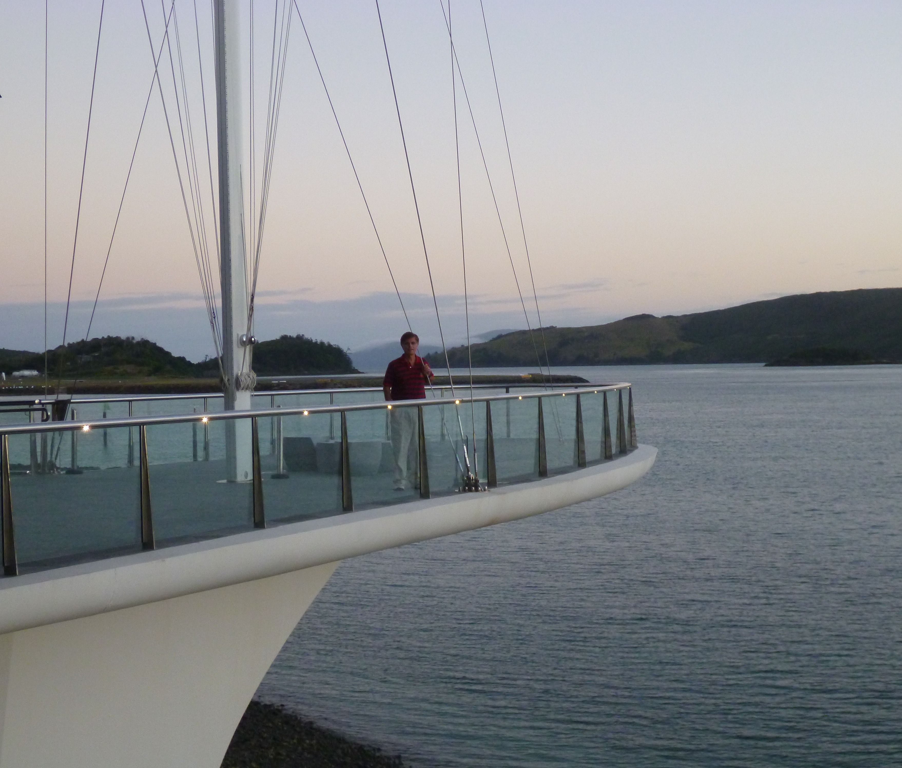
Back in the marina we made plans to go to the Great Barrier Reef with Cruise Whitsunday on a giant motor catamaran. Then we walked down to the Hamilton Island Yacht Club, a club for the yachtie aristocrats of Australia. It was an architectural masterpiece that evoked reverence and awe—and envy. It had sweeping lines that could be interpreted as a stylized whale, but many elements demonstrated its loyalty to the yachting world. The corners projected over water like the bow of a boat. The roof looked like a sail from many different perspectives. The stairs and railings could have been taken from a 150 foot luxury motor yacht. The hand rails were silky smooth mahogany. The door handles looked like the stylized hull of a 12 meter America’s Cup boat. The colors were elegant, restrained, and warm at the same time. And on one platform that projected over the bay, a mast stood with the flag of the Hamilton Island Yacht Club flying gloriously but discretely from the top. The overall impression of this structure was even more overwhelming than the Sydney Opera House, with which it bore some resemblance.

Thursday, June 13
No sailing today. We booked a tour on Cruise Whitsunday and went to the Great Barrier Reef, about 50-60 miles northeast of the Whitsundays. On the way there we saw two whales. One breached a couple of times, and the other repeatedly slapped its tail flukes on the water. The guide on the boat said that behavior might be to impress the other whale. It impressed us.

At the GBR Diana snorkeled while I dove. One dive cost $99, about double the normal price, but I saw about 10 times more coral than I usually see on two dives. The profusion of coral in all kinds of shapes and colors was astonishing. Diana enjoyed her snorkeling too.
When we got back to Hamiliton Island, there was only one thing left to do, but it was a big one—pack for the flight to Seychelles.
