Saturday September 14th – Skippers at 11:30 CDT – Meeting after, meal by Brandon is Chicken and Beef Stroganoff – Bring a side or dessert to share!
Saturday September 14th – Skippers at 11:30 CDT – Meeting after, meal by Brandon is Chicken and Beef Stroganoff – Bring a side or dessert to share!
Saturday August 10th – Check Facebook later in the week as its weather and wind dependent.

Skippers Meeting at 10:00 AM. Regatta and Dinner with Monthly Meeting to follow . Brandon is cooking Blackened Salmon Tacos. Please bring a side or dessert to share!


HI Guys We have postponed the Huddelston cup race that was taking place this Saturday because of the high-water level. We will not be holding the meeting and will move it to June 22nd. We will keep you posted on what races are going to take place. Thanks Tom.
Diana and I set sail from the Canary Islands on Tuesday morning last week bound for Florida. 400 miles south of the Canary Islands our chartplotter and autopilot failed. The nearest land was Cabo Verde, a group of islands off the coast of Africa about 450 miles away. We hadn’t planned to stop there but suddenly it seemed like a good idea. Hand steering on the open ocean is very tedious so we had to get our equipment repaired or replaced. Repair didn’t work so the owner’s wife flew to Lisbon,Portugal, picked up new equipment, and flew back here. We will install it tomorrow and hope to set sail by late afternoon. We are now about 2 weeks behind schedule so we have changed our destination to Barbados instead of Florida. Diana and I will fly home from there and the couple who own the boat will sail on to Grenada. Barbados is about 2100 miles from here, all downwind, so I think it should take us about 14 or15 days to get there. I had hoped to race in the Huddleston Cup Regatta, but that will have to wait until next year.
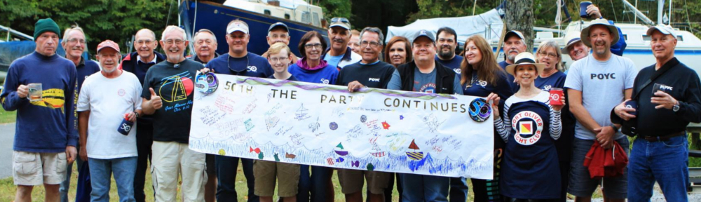
by Larry Cailouet
Masefield’s Star
In John Masefield’s famous poem he asks for a “tall ship and a star to steer her by” when he goes down to the sea again. Masefield lived before the days of GPS, chartplotters, and automatic pilot on boats. Today we are accustomed to knowing precisely where the ship is on the face of the Earth and exactly where the ship will be if it stays on its course. We don’t even have to steer the boat because the wheel and rudder are electronically connected to the GPS system. Just set the heading or the preferred wind angle and let the boat sail itself to the next port. Unless–unless the electronics fail. 400 miles south of the Canary Islands on our way across the Atlantic back to the USA our Garmin chartplotter quit working. Not a big problem–we still had chartplotters on our iPads so at any time we could know where we were and how far we had to go. Then 50 miles later the autopilot failed. The boat would no longer steer itself and we still had 2300 miles to go to reach Florida. That leaves only hand steering, a tedious business. Yes, we could feel “the wheel’s kick” and hear “the wind’s song” like Masefield wanted and see “the white sails shaking”, but this wasn’t what we bargained for. For a Sunday afternoon’s sail down at the sea, hand steering would be fun. You become more connected to the elements with every puff of the wind and every slap of a wave. God’s world is directly input to your hands and to the muscles in your arms and chest and shoulders. Your ears hear every flap of a sail and your eyes absorb every piece of information in the sky and on the sea in front of you. That’s good stuff, but for 2300 miles? No, I need not go down to the sea for that kind of punishment.
When the autopilot deserted the good ship Hello Beautiful we were 450 miles north of the Cape Verde Islands. We hadn’t planned to stop there at all, but you know what they say about any port in a storm. Perhaps in Cape Verde we could figure out what went wrong and repair the electronics. If not, perhaps we could purchase new instruments to give us a ride home. Yes, but what about the 450 miles between us and Cape Verde? Hand steering. That’s easy when you have fixed points of reference like that tall tree over there or that island in the distance, but on the open ocean you are in the middle of a 360 degree circle of water. Every wave and whitecap looks like all the others. Every point on the horizon looks like every other point.
Imagine this: You are driving a dogsled over the polar ice cap. As far as you can see to the left there is nothing but ice. As far as you can see to the right there is nothing but ice. Nothing in front of you but ice. No towns, no roads, no trees, nothing but ice, ice, and more ice. Your instruments go out and you can see no fixed points of reference. Polar winds shake the sled but you must stay on course or you could wind up on the wrong side of the planet. You are now hand steering.
So what do you do? You look for anything you can use to steer by. I don’t know what there is for that at the North Pole, but on the ocean we have the sky. By day there are clouds. You hope for some well-defined clouds. Some puffy white cumulus clouds would be nice. They have edges and shapes. I saw one that looked like a cat’s face with two little ears and another one that looked like a shark, complete with dorsal fin, pectoral fins and tail fin. But mostly I saw blobs and clumps or holes between the clouds. You can use these as reference points to see if your boat is turning toward them or away from them. The slot between the mast and the genoa makes a good viewpoint for this. But of course, clouds don’t stay in one spot. They drift so you have to frequently check your heading on the compass to see if your guide-cloud is still where you want to go. If it isn’t, you find a new cloud and work with it.
At night it becomes immediately apparent why Masefield wanted a star to steer his tall ship by. The stars stand out in a night sky and they don’t change shape. Constellations are identifiable and familiar. They even have names. The stars are steadier than clouds, so you don’t have to find a new star every few minutes. But they do move, so periodically you have to pick a new star or a new viewing point.
“I must go down to the seas again,” wrote Masefield, “for the call of the running tide is a wild call and a clear call that may not be denied.” Yes, but no hand steering please.

The Blessing of the Fleet is Saturday at 11am. It will be followed by lunch and the monthly meeting. Bring your favorite appetizer for lunch (Or hors d’oeuvers if you are feeling particularly fancy).
All reactions:
4Tom Cripps, Greg Glass and 2 others

This Saturday we will have the final spring workday in the morning and our April meeting folowing lunch. Lunch will be grilled chicken kebabs. I will have hummas and pitas. Please bring a side or dessert for the potluck.